

The United States of America commonly called the United States or simply America, is a federal republic comprising 50 states, the District of Columbia, and six territories and dependencies.
The total area of the United States is 3 720 407 square miles. The US is the world’s fourth largest state, after Russia, China and Canada.
The state originated with the Declaration of Independence of 1776: the national capital is Washington, D.C.
The main land mass of the United States lies in central North America, with Canada to the north, Mexico to the South, the Atlantic Ocean to the east and the Pacific Ocean to the west. The two newest states, Alaska and Hawaii, stand apart with Alaska bordering on northwestern Canada and Hawaii lying in the central Pacific.
On the Atlantic shore of the United States, the northern coast is rocky and uninviting, but the middle and southern Atlantic coast rises gently from the sea. The Appalachians, which cut down through the east, are old mountains. There are many valleys between them, and there is coal beneath. To the west of the Appalachians one finds the Great Central Lowland; the way its land lies resembles the plains of eastern Europe. Across the north of the Central Lowland, one finds the Great Lakes, which the US shares with Canada. The Great Lakes extend for almost 1600 kilometres, and are thought to contain about half of the fresh water of the world.
To the west of the Central Lowland one finds the Great Plains. They are like the flat top of a great table which is slightly tilted, so that the Great Plains keep rising to the west until they are stopped by the Rocky Mountains, “the backbone of the continent”. They are the same age as the Alps in Europe, the Himalayas in Asia, and the Ands in South America. Like those ranges, they are high, rough and irregular in shape.
The land west of the Rockies appears to be tumbled masses of mountains. Here one should mention the high Colorado Plateau, in which a mile-deep (1,6 кilometer) Grand Canyon of the Colorado River is cut, the high Columbia tableland and the Cascade Mountains formed by volcanoes. The Sierra Nevada range and the ridges of the Great Basin, on the other hand, were formed when an earth strain thrust a portion of the earth’s crust into high tilted blocks of rock. At the border of the Pacific Ocean are the Coast Ranges. These are relatively low mountains, where occasional earthquakes show that in this region the process of mountain building has not yet stopped.
|
PEAK |
STATE |
ELEVATION |
|
Mt McKinley |
Alaska |
20320 ft |
|
Mt Whitney |
California |
14494 ft |
|
Mt Elbert |
Colorado |
14443 ft |
|
Mt Rainier |
Washington |
14410 ft |
|
Death Valley |
California |
282 ft below sea level |
The Mississippi is one of the world’s great continental rivers. Its waters are gathered from two-thirds of the US. Together with the Missouri River (its chief western branch), the Mississippi flows some 4000 miles (6400 km) from its northern sources in the Rocky Mountains to the Gulf of Mexico. The Mississippi has been called the “Father of Waters”. Americans have had many bitter struggles with Mississippi floods.
The Mississippi’s principal eastern tributary is the Оhiо River.
Like the Mississippi, all the waters east of the Rockies finally reach the Atlantic; all the water to the west of the Rockies finally arrive at the Pacific, For this reason the Rocky Mountains are known as the Continental Divide.
The two great rivers of the Pacific side are the Colorado and the Columbia. The Colorado is in the South, the Columbia rises in Canada and drains the north.
The Rio Grande, nearly 2000 miles (3200 km) long, is the foremost river of the Southwest. It forms a natural boundary between Mexico and the United States.
The Great Basin is a strange drainage area. Its rivers seem to go nowhere. This region is so dry that the atmosphere sucks up its rivers or they sink into the sands before they can reach the sea.
The Great Lakes make up the largest group of lakes in the country. They are: Lake Michigan, Superior, Huron, Erie and Ontario (all fresh-water lakes).
The most famous salty lakes are the Great Salt Lake, in Utah, and the Salton Sea in Southern California.
THE RAINFALL AND THE ТЕМPERATURE
The Cascade Mountains and the Sierra Nevada Mountains catch the largest share of the rains that come from the Pacific Ocean. Almost the whole western half of the US lies in the “rain shadow” of mountains, which means that very little rain falls.
One of the most important geographic boundaries in the US is the 20-inch (51 centimeter) rainfall line which runs north and south, almost through the middle of the country. East of this line, farming is relatively easy, and the population is relatively large. West of the line one finds dry-farming, or man-made сгор-watering systems; and fewer people. East of the Rocky Mountains; running all the way from the Canadian border to Mexico, there are several hundred thousand square miles (kilometers) where almost no trees grow. In this section of the country, as well as in the Great Basin and Colorado Plateau to the west, there are deserts which receive as little as 5 inches (12,7 centimeters) of rainfall a year. Yet west of the Sierra Nevada Mountains, there are places in which 100 inches (2,54 metres) of rain falls every year.
All along the western coast, the temperature changes little between winter and summer, in some places the average difference between July and January is less than 10˚С. The climate along the northern part of this coast is similar to the climate of England or New Zealand. But in the north central part of the country, summer and winter are like two different worlds. There average difference between July and January is 36 ˚С and more violent extremes are common. The coldest days of a typical January may be – 40 ˚C and the hottest July day may be 48˚ Centigrade.
In the eastern part of the United Stales the difference between summer and winter is also very noticeable, but not so extreme. Near the south-western corner of the country, the climate is mild and springlike in winter, but in summer it is hotter than on the equator. In Alaska, almost continuous daylight in summer makes the short growing season an intense one.
Over a quarter of the country is still under forest, which ranges from the mangroves and swamp-forests of Florida to the huge Douglas firs and redwoods of the Pacific states, and from the hickory, walnut, and oak of the east central states to the pines of Minnesota and the Rocky Mountains.
The greatest wonder of all in the plant grows on the northwest coast, where the mountains catch the heavy Pacific rains. Here one finds the forests of huge sequoia and fir trees. Some of these great trees are 3000 years old. They are among the largest and oldest living things known.
The tall grass of the Great Plains becomes short grass farther west closer to the Rockies. The reason is clearly lack of rainfall. The line where the two kinds of grass change roughly follows the important 20-inch (51 centimeter) rainfall line.
TEN MOST IMPORTANT AMERICAN TREES
American beech, white oak, sugar maple, black tupelo, shortleaf pine, Douglas fir, redwood, Sitka spruce, western hemlock, ponderosa pine. Two American trees (i.e. American elm and American chestnut) have been badly depleted by disease.
The continental United States has more than 350 species of mammals, ranging from tiny shrews to the big brown or Kodiak bear which stands eight feet tall and may weigh as much as 1500 pounds.
Some of the bigger mammals, including the bison, pronghorn moose, bobcat and grizzly, once at the brink of extinction, have been saved. The Florida manatee, the red wolf and the prairie dog, however, are still in danger.
Some of the smaller mammals have flourished with civilization: chipmunks and cottontail rabbits are more numerous now than when the country was forested. Mice and squirrels, the deer and the fox, racoons and cougars, opossums and arm-adilloes can all be found m the US.
Alligators and crocodiles of the sloughs of Florida and the Gulf Coast used to be slaughtered for their hides. Crocodiles are virtually extinct there. Many reptiles are now protected by law (the horned lizard, box turtle, desert tortoise etc.)
There are 645 species of birds in the US including the California condor, the bald eagle, the mockingbird, the wild turkey, the ruffed grouse.
MINERAL WEALTH. POWER SUPPLIES
The United States has large reserves of almost all the more widely used minerals. These minerals include coal, petroleum, nuclear fuels (uranium and thorium), natural gas, iron, copper, bauxite (the ore of aluminium), lead, zink, stone, and many others. The country produces enough of some minerals to supply all its own needs and to ship to other countries as well. The US lacks a sufficient supply of some of the minerals required for modern industries. These must be shipped into the United States. They include tin, nickel, chrome, cobalt, industrial diamonds and asbestos. Most of the petroleum and natural gas deposits are located in California, on the High Plains and Gulf Coast Plain, the principal coalfields are in the eastern US, the main producing areas being in the Appalachian region.
Hydro-electric power has been developed on the Tennessee River, on rivers such as the Columbia, Sacramento, Colorado, at Niagara Falls, on the River St. Lawrence, and at many sites in New England. Uranium is produced in Colorado and several other Mountain States, and thorium in southern California and South Carolina.
There about 320 million people in the US, The national composition of the population is varied. Afro-Americans in the USA form 12,3 per cent of the population. The aboriginal Indians number half a million living on reservations scattered throughout the West and elsewhere. More than 700 000 people are of Chinese or Japanese origin. There are substantial Mexican minorities in the border states. There are also millions who came from Italy, Germany, Ireland and other countries.
The average density of population in the US is more than 50 per square mile.
The United States has 8 cities with more than a million people: New York (about 8 mil.), Chicago, Los Angeles, Philadelphia, Detroit, Houston, San Diego, and Dallas.
More than two-thirds of the population may be classed as urban. Only one in seven Americans actually lives on a farm.
California is the most populous state in the Union (about 32 mil people).
Wyoming with its 480 000 people (1995) is the most notably empty state.
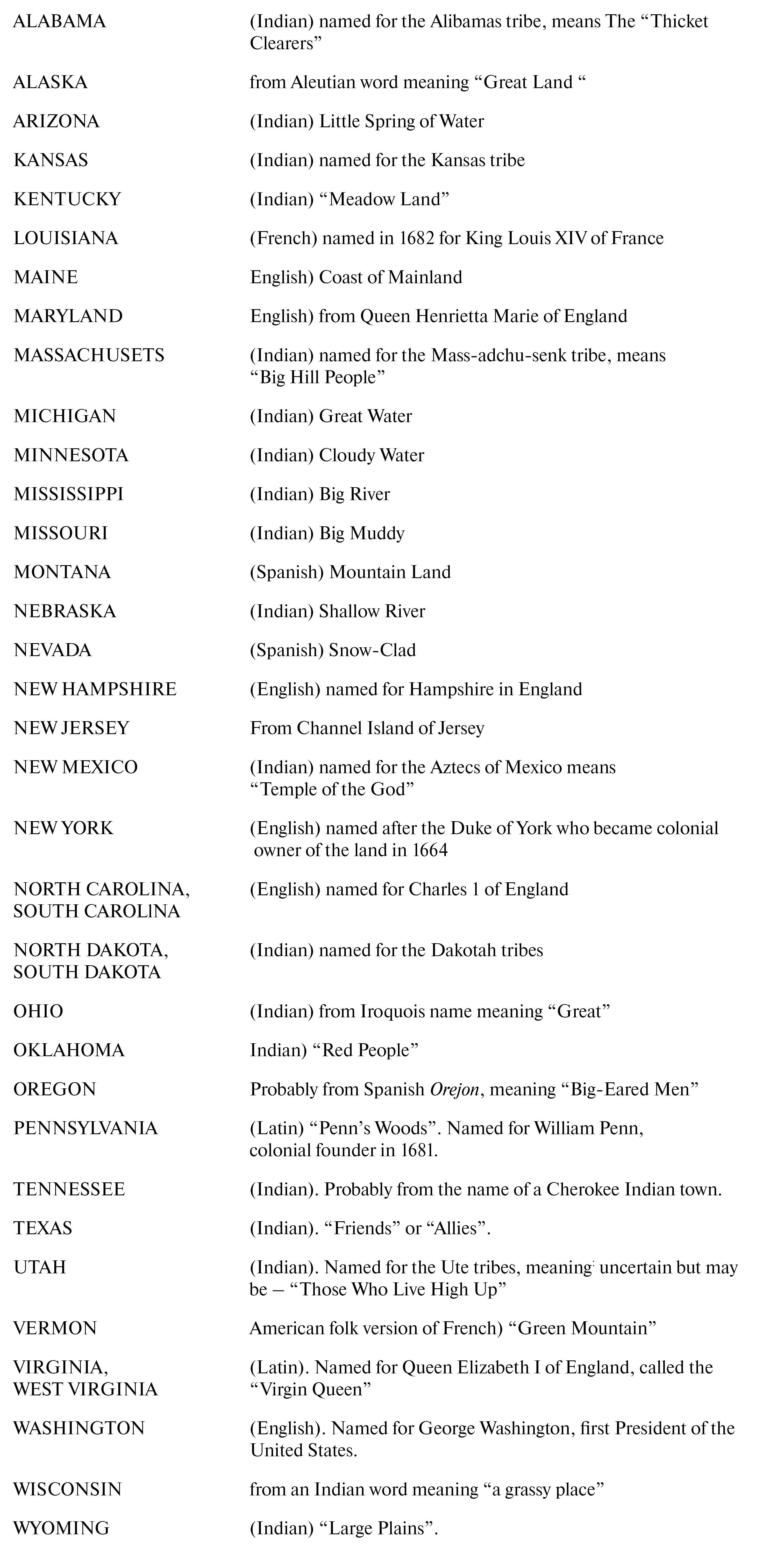
America’s place-names reflect the history of the country, ranging from those bestowed by the Indians before the white man arrived (Susquehanna and Michigan) to recent ones derived from scientific achievements (Atomic City, Idaho). The origins of the early settlers are clearly shown along the eastern seaboard by names borrowed from England (Boston and New Jersey), from Holland (Rensselaer and Tappan Zee), from Wales (Bryn Mawr and Bangor), and Germany (Lititz and Hamburg). In Florida, the Southwest and the West many are Spanish (Boca Raton, Santa Fe and Los Angeles); in Louisiana and the old Northwest Territory many are French (Baton Rouge and Eau Claire), and in Alaska there are a few remaining Russian names (Pribilof and Baranof, among others).
As memory of the mother tongues and countries in Europe dimmed the men responsible for naming towns, rivers and mountains turned to domestic sources. One was popular military and political figures: Washington, Jefferson, Jackson, Houston, Lincoln. The nature of the land, its flora and fauna, suggested descriptive terms:Boiling Springs, High Point, Elk City, Palm Beach, Bald Knob. Others were just made up: Penn Yan because it was settled by families from Pennsylvania and Yankees from New England, Texarkana because it straddles the border of Texas and Arkansas. The gold and silver rushes during the second half of the 19th century resulted in many a Silver City, and Silver Springs as well as Gold Stone and Gold Creek. The rough and ready pioneers of the West who did not stand on ceremony were also responsible for such picturesque nomenclature as Tombstone, Last Chance, Deathball Creek, Two Bit Gulch and Chicken Thief Flat.
The place-names of America show the panorama of the American World. Small clusters of homes, blinding white deserts, massed industrial plants, lakes known by the forefathers of the present Americans – there is no end to the contrasts among them. Even to look at these names is to begin a knowledge of the land.
People made the difficult and dangerous voyage to America for many different reasons. Some sought adventure. Others wanted gold and silver. Many made the voyage to escape oppression or to be free to practice their religion. Beyond these reasons was the additional drive for living space. Very few of the settlers could have hoped to own land in Europe. But in America, the land seemed to be there for the taking.
Waves of land-hungry settlers established farms and homesteads in the primeval forest. The forest was so vast and overpowering that each clearing was viewed as a victory in “taming the wilderness.”
In some places, however, after settlers cut away the trees and removed the brash, they found the soil to be rocky or poor in nutrients. Many areas of New England – the region now made up of Massachusetts, Maine, Connecticut, Rhode Island, New Hampshire and Vermont – have shallow, coarse soil. The winters are harsh and the growing seasons are short.
Under these conditions, pioneer farming in much of New England and parts of New York, New Jersey and Pennsylvania proved to be difficult and disappointing. After years of struggle, some people sold or abandoned their farms and moved westward in search of more fertile land.
Farther south, in what are now the states of Delaware, Maryland, Virginia, North and South Carolina, and Georgia, the soil was generally richer. Except for some swampy coastal areas, the soil is mostly red-yellow clay. And in early colonial times, that soil was very fertile. The long growing season, abundant rainfall, warm climate and relatively flat land made the southern coastal region ideal for certain cash crops. At various times, these included tobacco, rice, sugarcane, corn and cotton. By the mid-1600s, it was clear that these crops could be grown most economically on large landholdings – plantations – worked by slaves.
Many small farms in the South were sold to help make up the large plantations, and their former owners moved west in search of fertile land. They were joined by new settlers from Europe, who bypassed the settled plantation areas near the coast.
Most soil in the South was originally very fertile, but the continuous growing of demanding crops such as tobacco and cotton took nutrients from the soil. In addition, the frequent heavy rains of the region tended to erode – wear away – exposed topsoil. In many areas, this led to a decline in the yield of crops per hectare. Plantation owners often dealt with this problem of worn-out soil by expanding – by buying and using more land for their cash crops. Plantations spread to the west.
The European population of what is now the United States was scattered over a large area. The population density was very low. Farms, towns and villages were spaced far apart. Also, farms tended to be much larger than farms in Europe, partially because the yield per hectare was lower in America.
Except in the area near the seacoast, communication links between early American settlements were very poor. Roads were few and far between; those that existed were usually in terrible shape. To an extent, rivers served as communication links, but waterfalls and rapids often limited their usefulness.
As one traveled inland, the isolation of settlements increased. In search of fertile land, groups of settlers often bypassed large areas that they considered to be wilderness. As a result, a small settlement might be hundreds of miles from other settlements. A family might be a day’s journey from another family. This pattern of settlement created frontier communities that had to rely completely on their own resources. Almost everything they used they had to make themselves. They developed their own music, entertainment, folklore, art and forms of religious worship.
In this setting, a frontier spirit developed. It was marked by toughness, independence, self-reliance, caring for others, but a suspicion of outsiders. There was also a restlessness and a sense of curiosity in the frontier spirit.
At any given time during the long westward flow of American settlement (from the early 1600s to the late 1800s), the number of people on the frontier was tiny compared to the number of people “back East” in the settled areas. Yet, the frontier spirit has always had an enormous influence on the entire nation. Politicians have praised the frontier life. Songs and stories have described it in glowing terms. Such frontier heroes as Daniel Boone, Davy Crockett and Jim Bowie have been admired by generations of Americans.
Writing in the 1890s, historian Frederick Jackson Turner claimed that the frontier experience shaped the American character for all time. In his opinion, the geography and environment of America – particularly the westward expansion and the availability of free land – shaped American attitudes and institutions.
Turner wrote: “This perennial (enduring) rebirth, this fluidity of American life, this expansion westward with its new opportunities, its continuous touch with the simplicity of primitive society, furnish the forces dominating American character.” Not every modern historian agrees with all of Turner’s ideas, but most historians agree that the westward expansion of the frontier has had great significance in American history.
Many values and attitudes – good and bad – of present-day America can be traced to the frontier experience. The westward expansion stressed values of ruggedness, resourcefulness, self-reliance and comradeship. There was always a greater sense of equality on the frontier than in long-settled areas. After the American Civil War (1861–1865), many black Americans who had been recently freed from slavery moved west in search of equal opportunities. Many of these black frontiersmen gained some fame and fortune as cowboys, miners and prairie settlers.
Because the resources of the West seemed limitless, people developed wasteful attitudes and practices. Herds of buffalo (American bison) were slaughtered. Dry, flat grasslands (prairies) were badly farmed, and in years of drought much of the exposed soil blew away as dust. Open mines were used and abandoned. The western frontier was so large, and people there were so few, that it seemed that the natural resources could never be used up or destroyed. In more recent years, Americans have tried to conserve their resources better.
In 1700, European settlements in English-speaking North America stretched along the Atlantic coastline from southern Maine to South Carolina. While most settlements were less than 50 miles (80 kilometers) from the coast, a few were located further inland along tidal rivers. This was called “the tidewater phase” of settlement.
Over the next 50 years, the fertile river valleys in New England were settled; so was the valley of the Mohawk River in upstate New York. Settlers moving west from Philadelphia cleared oak forests of central Pennsylvania and produced an area of hilly green farms.
Settlements also spread westward along river valleys in Virginia and, to a lesser extent, in the Carolinas and Georgia. By the 1760s, the westward movement reached the first major barrier – the Appalachian Mountain Range. This mountain range stretches northeast to the southwest. It somewhat parallels the Atlantic coastline.
When they reached the foothills of the Appalachians, settlers found that most rivers flowing from west to east were blocked by waterfalls or rapids.
For a number of years, westward expansion was blocked. Then in 1775 explorer Daniel Boone (1734–1820) and a party of axmen cut the Wilderness Road through the forested Cumberland Gap, a natural pass in the Appalachians. The road through the Cumberland Gap enabled settlers to move with mules, horses and cattle into the fertile lands that now make up the states of Kentucky and Tennessee.
In 1803, agents of United States President Thomas Jefferson negotiated for the purchase of the vast territory from the I French emperor Napoleon. The Louisiana Purchase, stretching north from the Gulf op Mexico to the Canadian border and westward to the Rocky Mountains, almost doubled the land area of the United States.
All or parts of the present states of Louisiana, Arkansas, Oklahoma, Kansas, Missouri, Colorado, Nebraska, Iowa, North Dakota, South Dakota, Minnesota, Wyoming and Montana were acquired by the Louisiana Purchase.
The Louisiana Purchase also gave the United States a very large, very distinct geographic region known as the Great Plains, or Western Prairies. Around 1803, this was a region of flat or gently rolling land covered with tall grass. There were practically no trees, bushes or exposed rocks. Early travelers through the region called it “a sea of grass.”
In general, the Great Plains region is drier than the land east of the Mississippi. Rainfall ranges from around 40 inches (103 cm) a year on the eastern rim of the Great Plains to less than 18 inches (46 cm) a year in the western portion. Summers on the Great Plains can be very hot, about 110 degrees Fahrenheit (44 degrees Celsius), and dry. Summer rain, when it comes, is usually in the form of fierce thunderstorms. Both droughts and floods are common to some parts of the vast region.
On the Great Plains, the seasons of spring and autumn tend to be brief. Winters, particularly in Montana, the Dakotas, Wyoming, Nebraska, Iowa and Minnesota, can be very cold. Temperatures often dip as low as -40 degrees Fahrenheit (also – 40 degrees Celsius.) Fierce, windy snowstorms, or blizzards, are not uncommon.
At the time of the Louisiana Purchase, relatively few people lived in the Great Plains region. A number of Indian tribes – primarily Sioux, Pawnee, Comanche and Cheyenne – hunted on the Great Plains.
Unlike American Indians to the east, south and far west, these tribes did not live in permanent year-round settlements, nor did they grow crops. They survived by hunting, particularly the buffalo. And they moved with the buffalo herds.
For over 40 years after the Louisiana Purchase, white Americans did not move into the Great Plains in large numbers. During the first half of the 19th century, most westward-bound settlers viewed the Great Plains region as a place to cross on their way to more attractive lands on North America’s Pacific Coast.
Long before the Great Plains region was known to white people, there were European settlements along the California coast. They were created by Spanish missionaries, soldiers, traders and settlers moving north from below what is now the border with Mexico. They included San Diego, Los Angeles, Santa Barbara, San Luis Obispo, Monterey and, finally, San Francisco.
The Spaniards were not the only explorers of America’s Pacific Coast region. British, Russian and, later, American seafarers explored the coastline.
A number of American trappers and hunters followed the example of Lewis and Clark and explored new trails to the West. Because they spent much time exploring passes through the Rocky Mountains in California and the Oregon Country, they became known as the “mountain men.” They played a big role in the westward expansion of the United States.
The westward movement of Americans was spurred on by the idea that it was the “manifest destiny” of the United States to span the continent from the Atlantic Ocean to the Pacific Ocean. But California was firmly under Mexican control. Therefore, many Americans felt that the easiest way to expand the United States to the Pacific was by gaining sole control of the Oregon Country.
On June 15, 1846, the southern portion of the Oregon Country (made up of the present states of Washington, Oregon and Idaho with parts of Montana and Wyoming) became part of the United States.
A peace treaty between Mexico and the United States ended the war on February 2, 1848. It set the boundary between Texas and Mexico along the Rio Grande River. For a payment of $18,250,000 Mexico turned over the immense California and New Mexico regions to the United States. These regions include the present states of California, Nevada, Utah, Arizona and New Mexico.
Beyond the continental United States, Alaska was purchased from Russia in 1867 and the Hawaiian Islands were annexed to the United States in 1898. Both these regions did not become states until 1959.
In 1848, gold was discovered in California, though most Americans did not hear about it until the beginning of 1849. When they did, a massive “gold rush” occurred. The population of California increased from 15,000 in 1848 to about 260,000 in 1852.
Though the United States stretched from ocean to ocean in the late 1840s, the vast region between the Mississippi Valley and the western side of the Rocky Mountains was almost unoccupied. The thousands of people streaming west to California and Oregon saw it as just a difficult, dangerous place to pass through. They certainly did not view it as a desirable place to stay.
This thinking changed in the 1860s. A railroad was being pushed westward to span the continent. Some people realized that they could raise cattle cheaply on “the sea of grass” – the Great Plains- – and use the railroad to ship cattle to markets in the eastern states.
Cattle were allowed to graze freely on the plains and were rounded up once a year by cowboys. Ranches were marked off and a few towns were built along the railroad route. In the process, the great buffalo herds were killed off.
Of course, the Plains Indians bitterly resented the coming of the white people and the loss of the buffalo herds. So they fought back. Though the Indians won some battles, it was, in the long run, a losing cause. By the end of the 1800s, the tribes were scattered, living on government reservations.
As the Indians and the buffalo disappeared from the Great Plains, another group, made up mostly of small “homestead” farmers, moved in to compete with the cattlemen.
Starting in 1862 and continuing to 1900, the United States government offered 160 acres (65 hectares) of land to each family who would live on the land for five years and improve it. A small fee for registration of the land was also charged. Each lot of 160 acres was called a homestead and the farmers living on such a homestead were called homesteaders.
From the beginning, cajtle ranchers and homesteaders were in conflict. They represented different ways of life. Cattle ranchers and cowboys viewed the homestead farms as a waste of good rangeland. At first, the homesteaders’ crops were often eaten or trampled by free-roaming cattle, so the homesteaders started fencing their land with barbed wire. This increased conflicts with the cattlemen, particularly when a source of water was fenced in.
In time, the ranchers and farmers learned to live side by side. But their combined use of the land almost destroyed it. Unlike the buffalo herds of the past, cattle grazed the grass close to the soil. Farming was even more difficult on the prairie land. Plowing exposed the loose soil, and in periods of drought, the strong winds of the plains lifted the dry, powdery soil into the air. After a long period of drought in the 1930s, dust storms were frequent.
In an old frontier tradition, many people from the southern plains states abandoned their farms and moved west. But the age of the frontier was over. There was no more free land. Many of the people who moved to California during the “dust bowl” years had to work picking fruit on other peoples’ farms.
The frontier experience of moving westward and breaking new ground gave Americans several traditions. One was of independence, self-reliance and resourcefulness. Another, unfortunately, was a tradition of wasteful uses of natural resources. Land, water, timber and wild animals seemed so plentiful that people on the frontier thought these resources would never run out. For a long time it was easier and cheaper to abandon worn-out farmland than to nurse it back to productive use.
However, not all Americans feel this way. From the early colonial period, many Americans have argued for the preservation of forests, lakes and rivers and the careful use of farmland. Even the young George Washington, as a Virginia surveyor, was an early pioneer in conservation.
By the mid-1800s the need to conserve natural resources acquired a special urgency. The buffalo herds were rapidly disappearing. So were many other wild animals, including wolves, passenger pigeons, fur seals and sea otters. Forests were being destroyed by logging and forest fires. Rivers and lakes were being clogged and polluted with the waste of logging and mining.
Several naturalists called for action by the American people and government to save the nation’s natural heritage. Chief among them was John Muir (1838–1914). Muir, who was born in Scotland, roamed through the West studying and describing the natural wonders of his adopted land. He also campaigned vigorously for a national effort to save those natural wonders for future generations. It was largely through his efforts that wilderness lands were set aside as public parks. The first of these was the Yosemite Grant in California. This consists of a beautiful valley surrounded by cliffs and pinnacles. Giant Sequoia trees and other rare plants grow there.
Yosemite was made a national park in 1890, but it wasn’t the first. That honor went to Yellowstone, a 2,25 million-acre (one million hectares) tract of wilderness land established as a national park in 1871.
President Theodore Roosevelt, who knew and loved the vast, unspoiled beauty of the American West, began fighting for conservation as soon as he came into office in 1901. Sweeping provisions made to conserve the natural resources of the nation were among the most important achievements of the Roosevelt administration.
Many national parks and national forests were set aside as reserves after 1901, and a National Park Service was set up to administer them in 1916. The National Park system is an American example of conservation that has since been imitated by many countries around the world.
On every coin issued by the government of the United States are found three words in Latin: E pluribus unum. In Engish this phrase means “out of many, one.” The phrase is an American motto. Its presence on coins is meant to indicate that the United States is one country made up of many parts.
On one level of meaning, the “parts” are the 50 states that march across the North American continent and extend to Alaska in the north and Hawaii in the mid-Pacific. On another level, the “parts” are the nation’s many different peoples, whose ancestors came from almost every area of the globe. On a third level, the “parts” are the environments or geographical surroundings of the United States. These environments range from the rolling countryside of the Penobscot River Valley in central Maine to the snowcapped peaks of the Cascade Mountains in western Washington state and from the palm-fringed beaches of southern Florida to the many-colored deserts of Arizona.
From the .standpoint of government, the United States is one single country, of course. Its center is the national government in Washington, D.C. There are many other signs that the United States is indeed united – a national language (English) and a national coinage, to name only two. The many parts remain, however, making it difficult in some ways to gain an idea of the United States as a whole.
How, then, do Americans think of the United States? They often speak of it as a country of several large regions. These regions are cultural rather than governmental units. They have been formed out of the history, geography, economics, literature and folkways that all parts of a region share in common.
The development, over time, of culturally distinctive regions within a country is not unique to the United States. Indeed, in some countries, regionalism has acquired political significance and has led to domestic conflict. In the United States, however, regions have remained culturally defined, to the point that there are no easily demarcated borders between them. For this reason, no two lists of American regions are exactly alike. One common grouping creates six regions. They are:
- New England, made up of the northernmost five states along the Atlantic seaboard plus Vermont and parts of New York.
- The Middle Atlantic Region, composed of New York, New Jersey, Pennsylvania, Delaware and Maryland.
- The South, which runs from Virginia south to Florida and then west as far as central Texas. The region also takes in West Virginia, Kentucky, Tennessee, Arkansas, Louisiana and large parts of Missouri and Oklahoma.
- The Midwest, a broad collection of states sweeping westward from Ohio to Nebraska and southward from North Dakota to Kansas, including eastern Colorado.
- The Southwest, made up of western Texas, portions of Oklahoma, New Mexico, Arizona, Nevada and the southern interior area of California.
- The West, comprising Colorado, Wyoming, Montana, Utah, California, Nevada, Idaho, Oregon, Washington, Alaska and Hawaii.
Defining the six main regions of the United States does not fully explain American regionalism. Within the main regions are several kinds of subregions. One type of subregion takes a river valley as its center. Thus, historians and geographers often write of the Mississippi Valley, the Ohio Valley or the Sacramento Valley. A second type of region is centered around mountain areas such as the Blue Ridge country of Virginia or the Ozark country of Arkansas and Missouri.